Road Closures,
Conditions & Notices

🔥 UPDATE: Fitzgerald River National Park - Post January 2026 Bushfire
 
🌳  A park closure notice remains in place by WA Parks and Wildlife Service for the Fitzgerald River National Park with PARTS of the national park closed due to the January 2026 bushfire. Entry into the national park along the sealed section of Hamersley Drive (south) near Hopetoun, has not been affected and vehicles are able to access all attractions along this route which ends at Hamersley Inlet. The Hakea Trail is open for hikers including access to the Whalebone campsite. 
 
Since the fire, recreation sites within the Fitzgerald River National Park have started to open once inspections had taken place and there is no risk to the public. Visitors should refer to the DBCA Park Alerts page to find out which sites are still affected or contact DBCA's Albany Regional office directly on (08) 9842 4500 or email albany@dbca.wa.gov.au.
 
Affected sites include:
  • Hamersley Drive (north) unsealed section
  • Quoin Head track
  • Whalebone Track
  • Moir Track
  • Pabelup Drive
  • Twertup Track
  • Mamang Walk Trail
 
In addition to the closures as a result of the fire, road and attraction access may change at short notice due to wet weather conditions. Please refer to the latest Parks and Wildlife's Road Condition Access Report below which gets updated regularly for the most recent information.
 
MAIN ROADS WA NOTICES

To stay up to date on road conditions please visit Main Roads Travel Map or by calling 138 138.  Main Roads Travel Map is a great resource for the latest alerts on traffic and travel information relating to Western Australia's main road network. 

The maintenance of the following roads are the responsibility of Main Roads WA:
 
South Coast Highway
Brookton Highway (ie Lake King - Ravensthorpe)
Ravensthorpe-Hopetoun Road
 

Please report any road faults or hazards to https://www.wa.gov.au/service/transport/road-transport/report-road-fault-or-hazard 

All enquiries please contact Main Roads Great Southern Region (08) 9892 0555.
  
🚧 Main Roads WA: mainroads.wa.gov.au
 

SHIRE OF RAVENSTHORPE NOTICES

With the warmer weather brings more movement of our wildlife in the region. Drivers are advised to be aware and help protect our wildlife. A reminder for your safety, when travelling on unfamiliar roads, always drive to the road conditions and ensure you take sufficient rest breaks on long road trips.

For more information on local road conditions and closures within the Shire of Ravensthorpe please contact (08) 9839 0000 during office hours, between 9AM to 4PM or visit the Shire of Ravensthorpe website or Facebook page

For the latest updates information on local Esperance roads please contact the Shire of Esperance:

🚧 Esperance Road Report page: esperance.wa.gov.au/roadreport or call (08) 9071 0666.
Please note access to Munglinup Beach Caravan Park from South Coast Highway is available via Fuss Road (sealed).
  

WHERE DO I FIND INFORMATION ON THE CONDITION OF ACCESS ROADS INTO THE FITZGERALD RIVER NATIONAL PARK?

There are several access points to enter the Fitzgerald River National Park, however the status of these roads may change at short notice. These roads are managed by the Department of Biodiversity, Conservation and Attractions (DBCA), Parks and Wildlife Service.

To help protect the unique biodiversity of the Fitzgerald River National Park, which is the core of UNESCO recognised biosphere reserve, unsealed roads and tracks are closed during wet weather conditions to help prevent the spread of dieback disease.

Dieback is caused by the microscopic invasive plant pathogen Phytophtora cinnamomi, a soil-borne disease that causes root rot and kills native plants. It spreads easily in mud and soil on vehicles, boots, tyres and equipment, especially in wet conditions. Once dieback arrives in a landscape it cannot be removed and every visitor can help stop the spread by adhering to any road closures, staying on designated tracks and trails and ensuring you always clan vehicles, boots and equipment BEFORE and AFTER leaving natural areas.
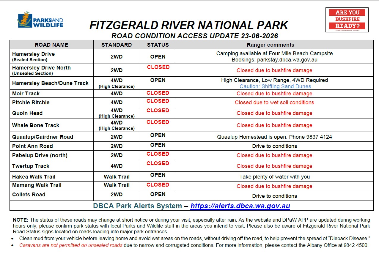
Updated Saturday, 13 June 2026

Important Safety Notice:

DBCA is currently undertaking road maintenance works along Point Ann Road (on the western side of the Park). Due to ongoing works and associated hazards, the road has been closed in the interest of public safety and will remain closed until Friday 12/06/2026.

Please avoid the area and adhere to all road closure signage and directions to ensure their safety and the safety of maintenance crews

Visitors should also be aware that access to the Hamersley Dune Track within the Fitzgerald River National Park will be limited in some areas due to sand migration. Please take extra care and caution when accessing the track.

Further updates on the roads, tracks, walk trails and campgrounds (excluding Hamersley Inlet Campground which is managed by the Shire of Ravensthorpe),or any closures can be found by contacting the DBCA's Parks and Wildlife Service  Albany office  during office hours on (08) 9842 4500 or by visiting the Park Alerts System alerts.dbca.wa.gov.au/

For information about the condition of roads leading to the western side of the Fitzgerald River National Park can be obtained from the Shire of Jerramungup or visit the Road Conditions page on their website.


🚧 WHY DO THE ROADS CLOSE SO FREQUENTLY IN THE NATIONAL PARK?  

To protect the biodiversity of the Fitzgerald River National Park from the risk of spreading Phytophthora dieback (a deadly plant disease), which is carried by muddy soil sticking to tyres, shoes and equipment, Parks and Wildlife will close unsealed roads and tracks during wet weather events and re-open when the conditions are sufficiently dry (often at short notice).

It is not uncommon for lengthy road closures during the winter months when it is more likely to rain and the soil taking longer to dry. The mild winter conditions experienced in the Fitzgerald Biosphere Coast means that there are times when it is warm and dry enough for the roads to re-open albeit for a short period between the next rain event.

For visitors planning to attend the western side of the National Park (near Bremer Bay) with the aim to get to Point Ann (a natural whale nursey during winter) and St Mary's Inlet campground, it is important to note that all of the roads and tracks in this section of the Park are unsealed and it can be a hit and miss as you are at the mercy of Mother Nature. The chances of access increases greatly with the warmer months, however, until there is sealed access, there can be no guarantee.

The good news if travelling to the eastern side of the National Park (near Hopetoun), Hamersley Drive south is sealed up to Hamersley Inlet and accessible 24/7 except on rare occasions due to alerts relating to extreme weather conditions or bushfire when roads closures may apply for visitor safety. Currently, this is the only sealed road within the National Park but still provides visitors with plenty to see and do including access to key attractions (Cave Point, East Mt Barren), walking trails and the two online bookable campgrounds: Four Mile (Parks and Wildlife) and Hamersley Inlet (Shire of Ravensthorpe). Please note that the northern section of Hamersley Drive which adjoins West River Road and connects with South Coast Highway is however, unsealed and similarly to the western side can close after rain.

The report above is provided to keep you informed on the current status of roads to assist you with your planning. For more information on the Fitzgerald River National Park, please click here (this will take you to Parks and Wildlife Services Explore Parks website). Please regularly check the road conditions and closures before heading out especially after heavy rain as gravel roads and tracks may be closed at short notice. There are digital signs at various entrances to the park to assist you with the status of current road closures, however please be mindful that due to size of the park there may be a short time lag between Rangers closing roads and road notices being issued.

Hamersley Drive south from Hopetoun - is a beautiful, scenic sealed road (bitumen) right through to Hamersley Inlet that will provide plenty of photo opportunities, so don't forget to bring your camera!

Hamersley Drive (south), Photographer Dene Bingham